You have a ladder stand above a creek bottom and a rifle you trust. Whether you get a shot you should take at the buck crossing the far flat is mostly decided before the season: by what you can see from that tree, how far and how steep the shot is, and what sits behind him.
For planning only. Reckonar’s Shot layer and setup rankings are estimates to help you plan. They come with no guarantee and are not a safety check. In the field, use your own judgment and follow the law and safe-shooting rules.
The short version
- 01A Reckonar Plan ranks a setup by the deer presence it could reach with an ethical shot. Deer that pass out of range or out of sight add nothing.
- 02Each main setup in a saved Plan keeps a Shot layer that maps where your sight lines are clear and where brush or terrain blocks them.
- 03Reckonar never verifies a backstop. It treats every bearing toward an area you mark Off limits / no shot as dangerous, even when that area lies beyond your range.
Four checks before you draw
A Plan checks four things from the map for every setup.
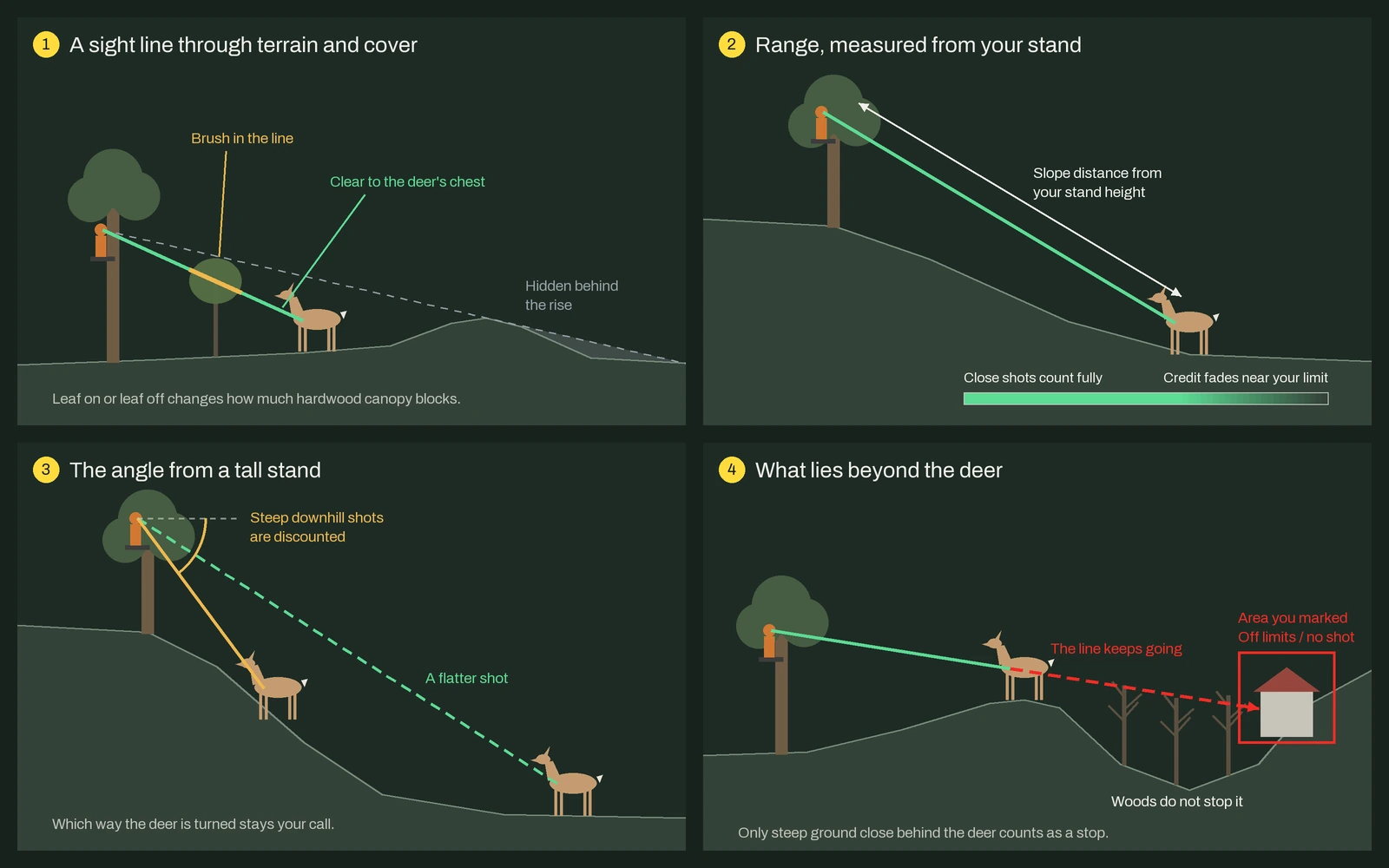
Terrain comes from USGS 3DEP elevation and lidar. Brush and canopy come from USGS lidar wherever it passes quality checks, down to single trees, and from LANDFIRE vegetation maps elsewhere. You choose a weapon and leaf on or leaf off in Plan a Hunt, and the Plan applies an effective range for that weapon class.
How a Plan ranks setups
A bedding thicket can hold the most modeled deer in rifle range and almost no ground you could shoot into. So a Plan counts only the deer presence you could take an ethical shot at during your hunt hours. Partial cover reduces that credit, shot lines toward an off-limits area earn nothing, and a setup whose scent would carry into bedding loses credit or drops out.
The Opportunity view scales each setup from 0 to 100 against the best one in the same Plan. A 50 is half the modeled opportunity of the best setup, not a 50 percent chance of a shot. Favoring close, open shots means fewer marginal shots and fewer wounded deer.
Reading the Shot layer
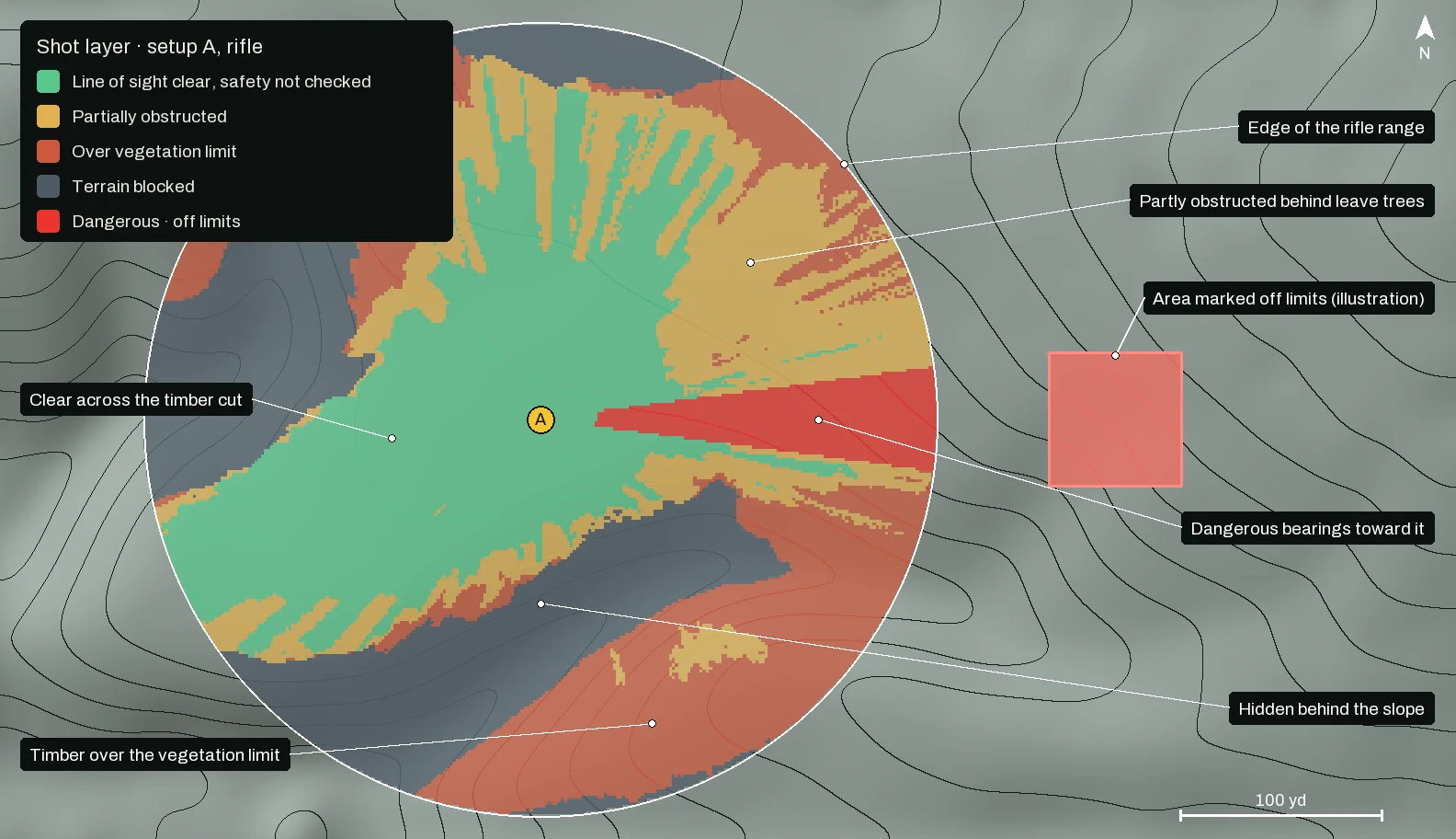
The map at the top is setup A’s Shot layer from a saved rifle Plan for a leaf-off November 14 on the GWNF - James River demo Hunt Area, rerun offline with the current model; we added its off-limits area as an illustration. Setup A sits in an old timber cut: clear across the cut, partly obstructed behind its leave trees, and over the vegetation limit in the timber beyond. Green reads “Line of sight clear, safety not checked,” because a clear line says nothing about what stands behind the deer.
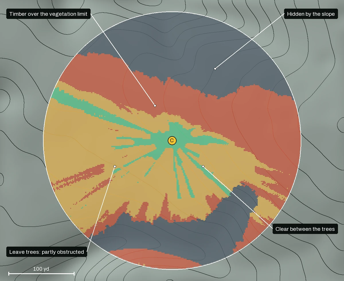
The ranking gives partial credit for a view through thin cover, while the Shot layer draws a hard line at the vegetation limit for your weapon. When the two disagree, walk the ground.
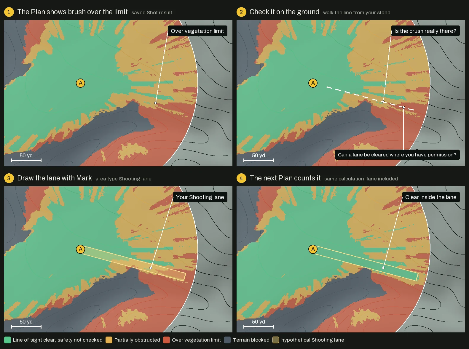
A Plan generated after you draw the lane also uses it when it ranks setups.
What lies beyond the deer
A missed bullet keeps going far past any range you would shoot. Reckonar cannot see a cabin or a road until you mark it, and every Plan says so.
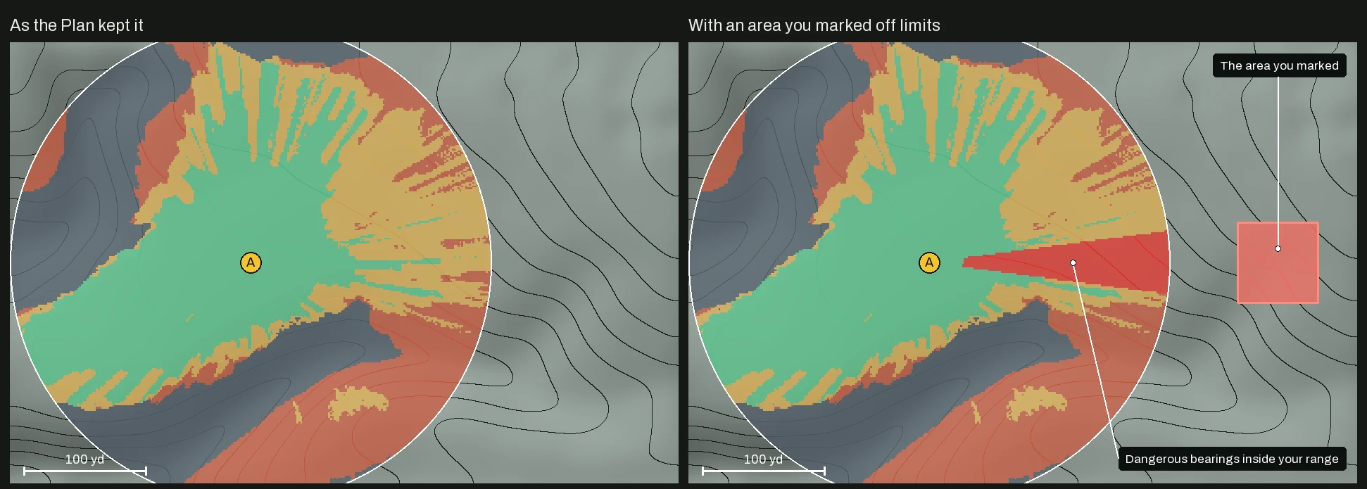
The hazard check follows a straight line and ignores bullet drop and ricochet. It gives woods no credit as a stop. A real backstop is earth, such as a steep bank close behind the deer.
How we test the line of sight
We compared Reckonar’s terrain line of sight with an independent GIS tool on twelve USGS 3DEP elevation grids in five states.
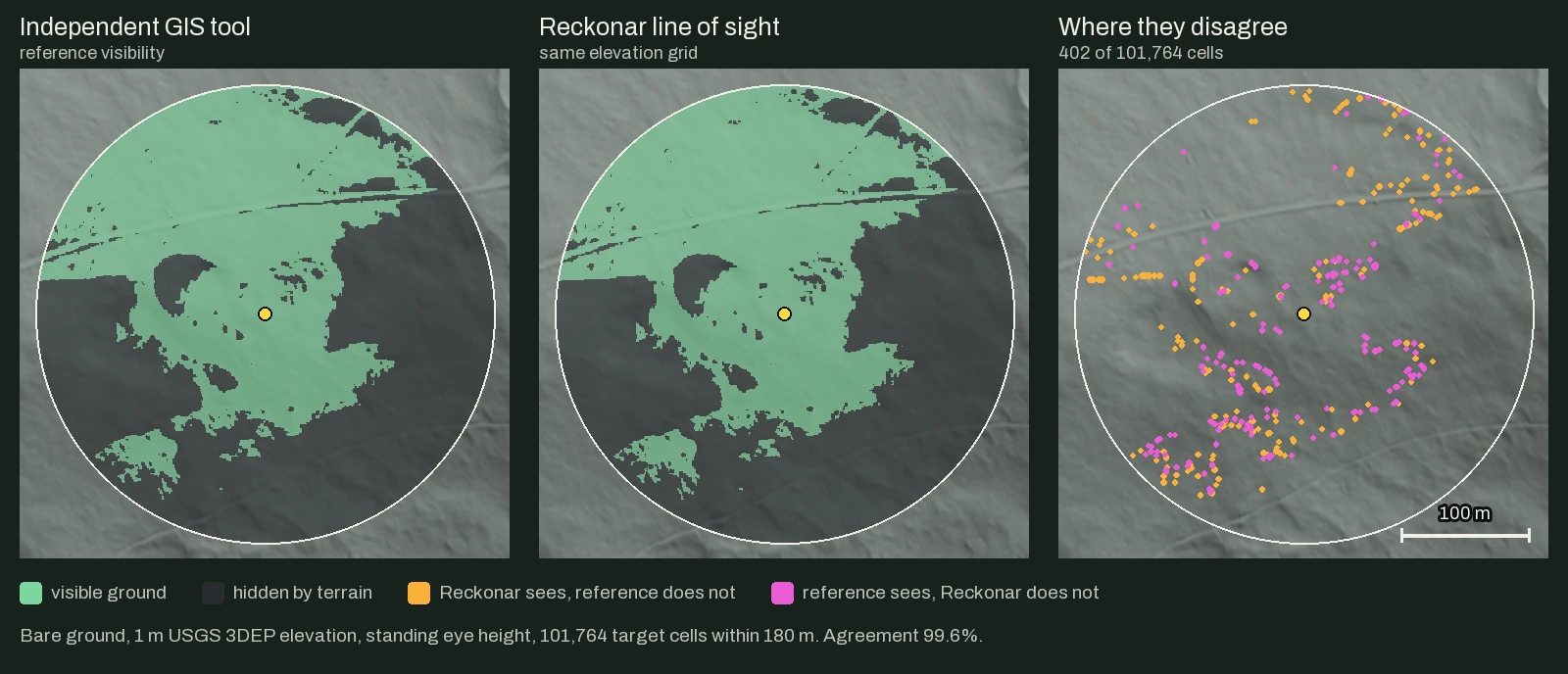
Over about four million pairs they agreed on 98.2 percent. The Shot layer’s configuration agreed on 99.4 percent on the three 1 m grids.
What we don’t claim yet
- Not a safety check. The app adds its own warning: “Verify your target, actual obstructions and what lies beyond it. A backstop remains unverified; woods do not count as one.”
- Calibration. Scores are relative and have never been compared with real hunt outcomes.
- Vegetation. Lidar is a snapshot: James River’s was flown in 2017, so regrowth since then still reads open. Without usable lidar, land-cover maps miss understory and small openings, so walk a modeled lane before you trust it. Vegetation and hazard handling are tested only on synthetic cases.
- Terrain. The line-of-sight test is bare ground, and a narrow berm can slip between samples.
- Deer and range. Which way the deer is turned is not modeled, and you cannot yet enter your own effective range. On a large Hunt Area, bow range spans only a few analysis cells, so bow results are coarse.
Where to find it in Reckonar
- Plan a Hunt (Field, then Plan) holds the Weapon and Foliage settings.
- Saved Plans live in Content. Mount one, pick A, B or C in the Plan tray, and turn on Shot.
- Mark, then Draw map area, creates an Off limits / no shot area or a Shooting lane. A saved Plan keeps its old evidence, so generate a new one afterward.
- Tools shows Ethical shot greyed out as Coming soon.
Reckonar is for planning before and between hunts. It never tells you where a deer is while you sit.