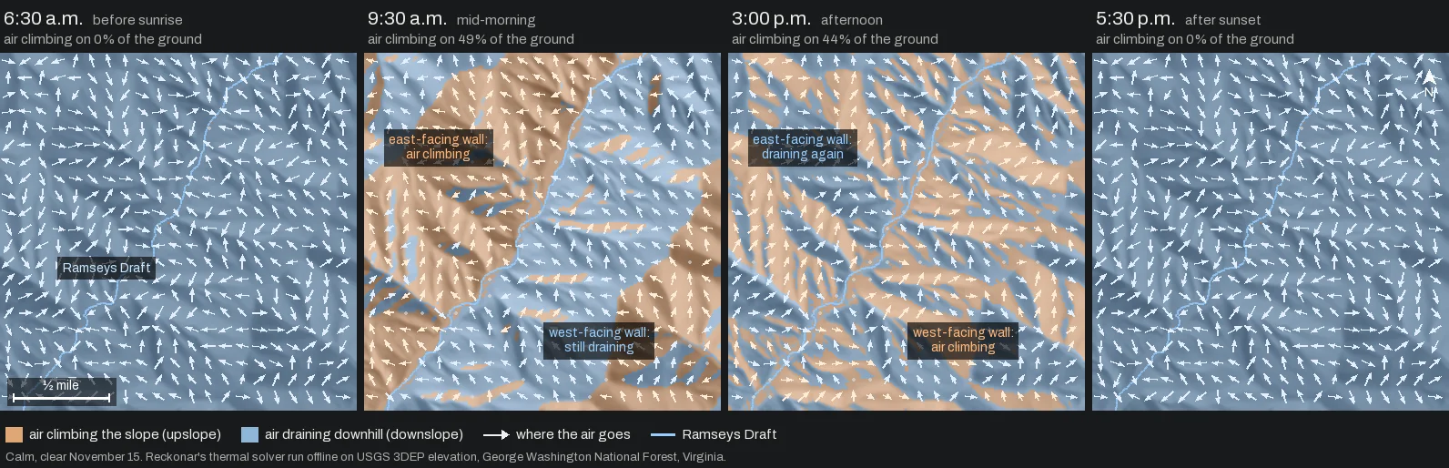
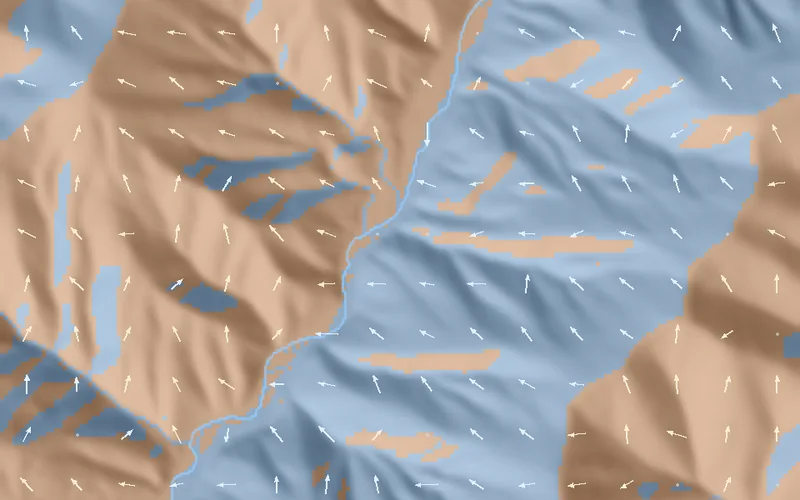
You climb to a bench above the creek in the dark, and cold air slides past you toward the bottom. By nine the sun is on the face across the hollow, and the air over there has turned uphill. Your face is still in shade, and your air is still draining. “Thermals rise in the morning” is right about that far slope and wrong about yours.
The short version
- 01On a calm, clear November 15 in Ramseys Draft, Reckonar’s model turns the air uphill on east faces soon after sunrise and on west faces around 11 a.m.
- 02At midday a third of the ground is still draining. Steep north faces never turn.
- 03Ridge shadows delay the switch. Under a long ridge on our James River demo Hunt Area, the air climbs on a quarter of the ground only at 9:15, more than an hour after Ramseys Draft.
- 04In early October only 3 percent of the same ground drains all day. By mid-November it is 23 percent, because the sun rides lower.
The ground and the sun
We ran Reckonar’s thermal solver offline on about 2,200 acres of public land over Ramseys Draft in the George Washington National Forest, Virginia, using USGS 3DEP elevation. The Draft runs northeast to southwest, so the slope on its west side faces east, the slope on its east side faces west, and side hollows face every other way.
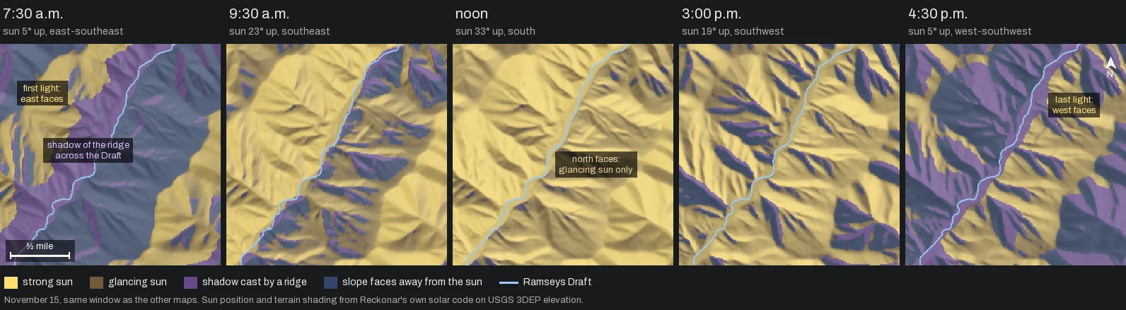
Slope breezes start with sunlight. Reckonar works out where the sun is for your date and place, how squarely it strikes each patch of ground, and whether a ridge blocks it. Its sun positions agree with an independent astronomy library to within a third of a degree, and its sunrise and sunset times match U.S. Naval Observatory tables to within a minute.
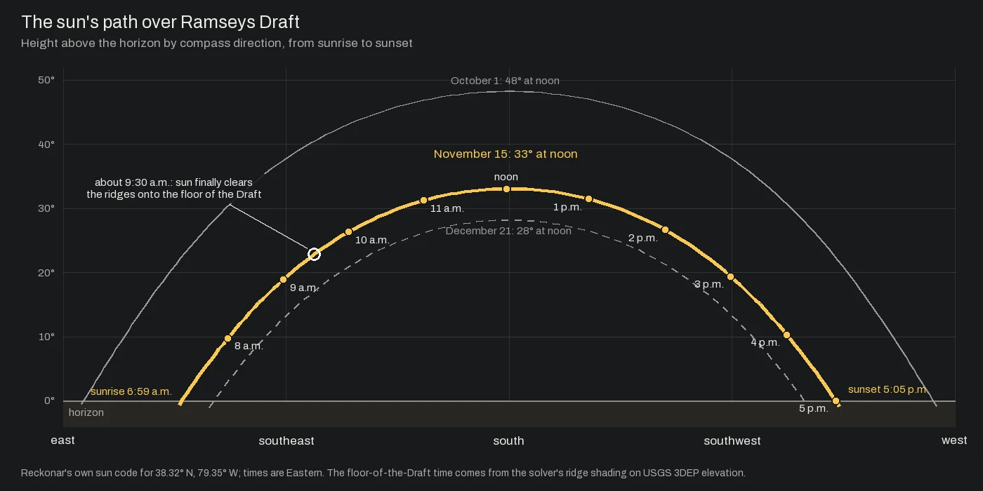
James River lies 42 miles southwest, on the northwest flank of a long ridge. At 8 a.m. the ridge shades 42 percent of its ground and the air climbs on 6 percent, against 23 and 26 percent in Ramseys Draft. Glancing light does not turn the air, so the switch lags even after the sun clears the ridge. In late afternoon the order flips, and James River keeps its sun longer.
What the air does
Before sunrise the model drains cold air down every slope into the hollows and along the creek. When the sunlight on a slope gets strong enough, its air turns and climbs, and when the light weakens or leaves, it drains again.
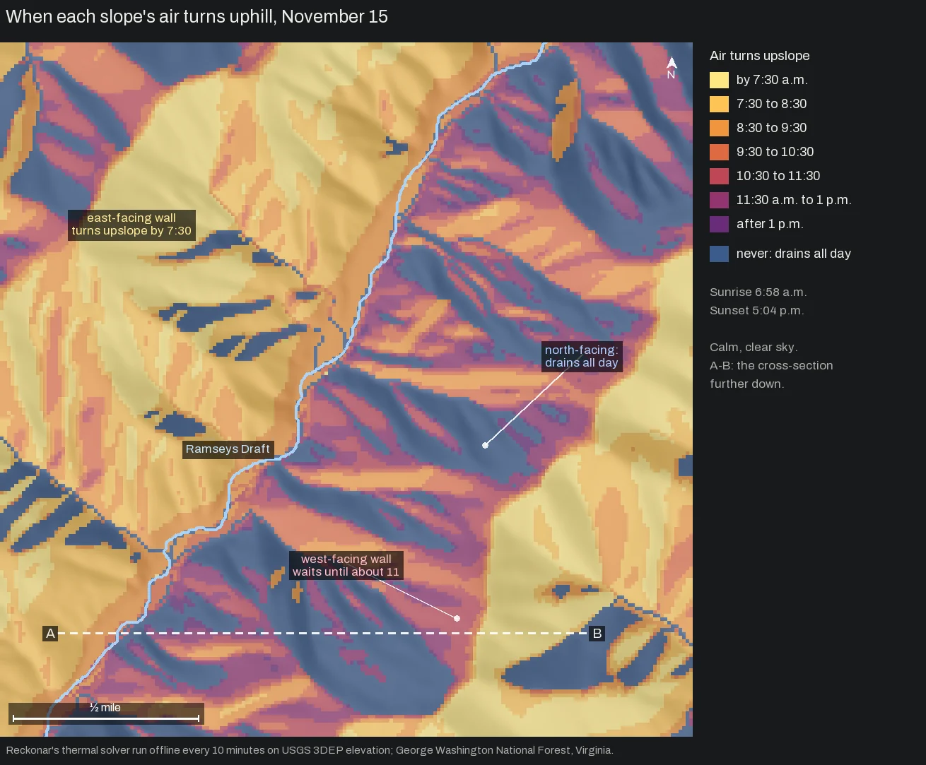
More than half of the east faces turn within half an hour of sunrise. South faces follow around 8:00, southwest faces around 9:30 and west faces around 11. By 2 p.m. nearly every east face drains again, while most west faces keep climbing past 4.
Ridge shadows add their own delay. With terrain shadows switched off, the same day’s switch came half an hour or more earlier on about one slope in six, more often in hollows than on open faces.
One ridge, two directions
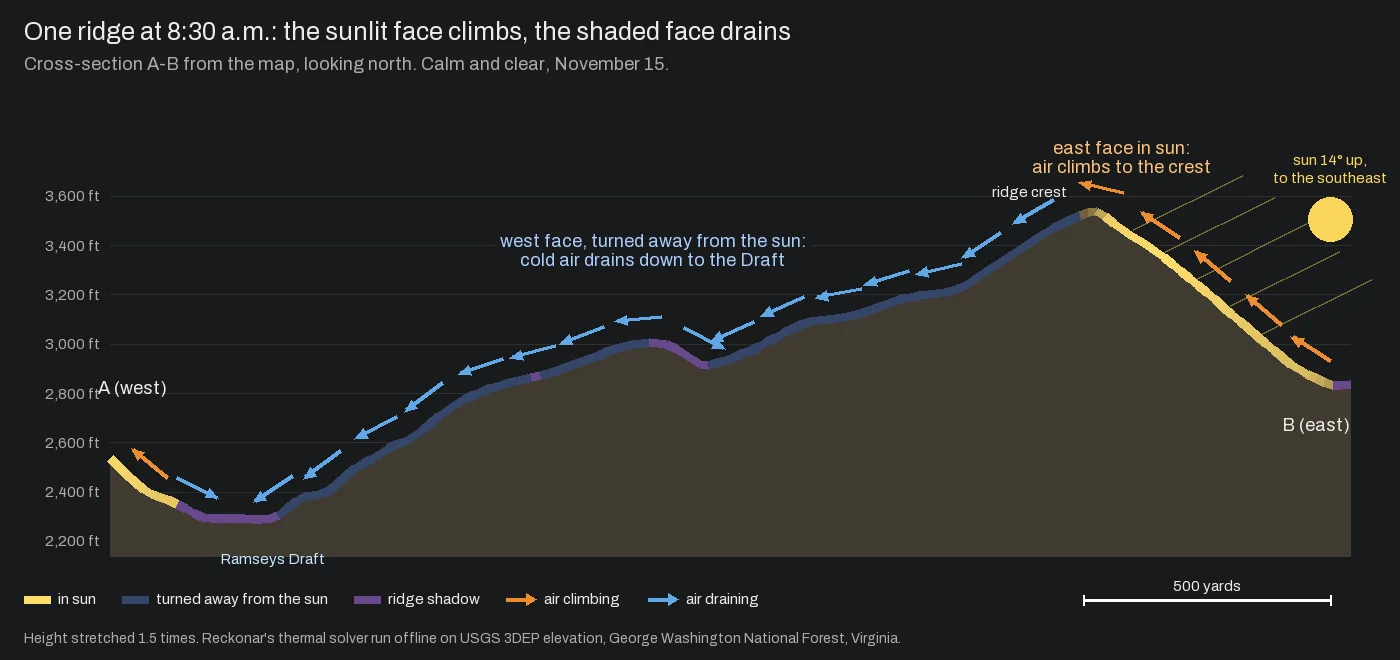
A hunter on this ridge’s west face at 8:30 has air sliding downhill toward the Draft. A couple hundred yards over the crest, air climbs toward the ridgetop. Scent goes opposite ways at the same minute, and that decides which deer can smell you (how a deer notices you).
November changes the map
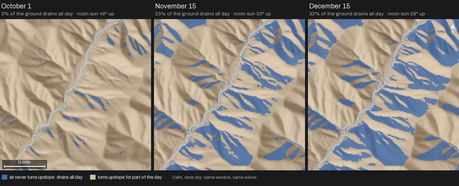
In early October nearly every slope here climbs for part of the day. By mid-November almost every steep north face drains from dawn to dark.
Breezes and clouds
These maps assume calm air and a clear sky. As the regional wind picks up, the model weakens the slope breezes under it, so on a breezy day the terrain-steered wind carries most of your scent. Within NOAA’s 48-hour HRRR forecast, cloud cover weakens both the daytime climb and the drainage. Farther out, and in Plans built on historical winds, the model assumes a clear sky.
What we don’t claim yet
- Thermals pass behavior tests only, with no field comparison against measured slope winds yet.
- The model has no warm-up time. A slope turns as soon as its sunlight is strong enough, while real ground takes time to warm, so expect the real switch later, especially after a hard frost.
- Forest canopy does not yet change thermal timing or direction.
- Cold air collects in the hollows without a modeled pool depth.
- Only terrain loaded around your Hunt Area casts shadows, so a big mountain farther off can shade a valley longer than the model shows.
- The switch-time and season maps are offline review renders. The app shows thermals hour by hour.
Where to find it in Reckonar
In Field, the Wind layer includes the modeled slope breezes for each hour, under Prevailing, Today’s conditions or a mounted Plan. In Plan a Hunt, calm hours in the station records become their own wind, Calm · thermals only, which you can pick in the Plan tray. Expand a mounted Plan’s timeline and its Conditions rows show Thermals at your stand (upslope or downslope), Cold drainage and Sun and shadows, with a Thermal switch mark when your stand’s air turns.
Plans are built before you go, from terrain, sun and weather records. Nothing here measures the air on the mountain while you hunt.